|
|
|||||
|
Research This research project is planned for a period of 2 years with
the following four tasks and milestones (management meetings will be held
every quarter to monitor the project progress):
Task 1: Analyze existing technologies; initial
design of the proposed MCSDSS system; group teleconference meeting to
finalize the research tasks to develop the proposed system. Design and
develop spatial-temporal databases system for MCSDSS fire response; integrate
social and infrastructure data pertaining to municipal/corporate fire risks
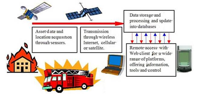
and location-aware information from emergency assets Task 2: Develop location-aware low-cost sensor
system on fire emergency response assets including real-time data acquisition,
in-sensor embedded data management, data transmission and access; Develop MCDA models and emergency
management systems including ANP system for MCSDSS and integrate MCDA and
geo-spatial technologies. Task 3: Develop a MCSDSS fire response prototype
system by integrating all functions and components including hardware and
software integration; assess the prototype system under operational
environments and analyze the performance with respect to a number of
parameters. Develop graphical user interface and conduct sensitivity analysis
for MCSDSS fire response; develop methods for data integration in decision
making and the optimization of the interaction between the computer system
and the user Task 4: Field-testing
will be conducted to confirm the ability of the MCSDSS to receive and send
messages from location-aware sensors using efficient wireless technologies. Demonstrate the prototype system to fire emergency
service agencies in collaboration with our project partners and develop plans
to transfer the developed technology to support operational implementation. |
|||||
|
|
|||||